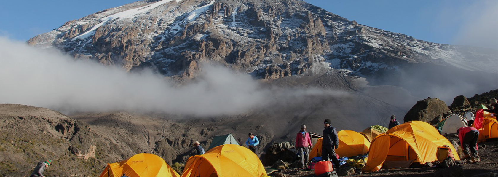
Lemosho Route is the longest of the standard routes and is without doubt the most beautiful. Expect some of the most extraordinary scenery anywhere in Africa, with well-preserved forests, sweeping moorland, heather forests and high desert. Lemosho Route also offers easy walking days and plenty of opportunity for altitude adjustment.
The route approaches the summit from the west via the Londorossi Gate and one of the most remote quarters of the region. The trailhead is little more difficult to reach, so Lemosho can sometimes be more expensive options.
- Day 1
Londorossis Gate to Mti Mkumbwa
Elevation: 1830m / 6000ft to 3050m / 9950ft
Distance: 11km / 7mi
Hiking Time: 5-6 hours
Habitat: Montane Forest
After breakfast and briefing, drive to Londorossi Park Gate (about a 3-hour drive). From here a forest track requiring a 4WD vehicle leads to Lemosho Glades. Walk along forest trails to Mti Mkubwa (big tree) campsite.
- Day 2
Mti Mkubwa to Shira Camp
Elevation: 950 m / 3116 ft
Distance: 12km / 7.5mi
Hiking Time: 5-6 hours
Habitat: Moorland
After breakfast, we continue as the trail gradually steepens and enters the giant heather moorland zone. After several streams are crossed we continue over the Shira Ridge past the Shira 1 camp and on to the Shira 2 camp on moorland meadows by a stream.
- Day 3
Shira Camp One to Shira Camp Two
Elevation: 3850m / 12,600ft to 4000m / 13,000ft
Distance:8km / 5mi
Hiking Time: 5-6 hours
Habitat: Semi - Desert
From the Shira Plateau we continue to the east up a ridge, passing the junction towards the peak of Kibo with possible side trips to Shira Cathedral. As we continue, our direction changes to the South East towards the Lava Tower, called the “Shark’s Tooth” (elev 4650m/15,250ft). Shortly after the tower we come to the second junction which goes to the Arrow Glacier. We now continue down to the Barranco Camp. Although you end the day around the same elevation as when you began, this day is very important for acclimatization and will help your body prepare for summit day.
- Day 4
Elevation: 4700m / 15,500ft to 5895m / 9,340ft
Distance: 6km/4mi up
Hiking Time: 6-8 hours
Habitat: Alpine Desert
After breakfast, we leave Barranco and continue on a steep ridge up the Barranco Wall (elevation 4250m/13,900ft), through the Karanga Valley (elev 4050m/13,250ft) to the junction which connects with the Mweka Trail. We continue up to the Barafu Camp. You have completed the South Circuit, which offers views of the summit from many different angles. Here we make camp with views of the summit in the distance.
- Day 5
Elevation: 4050m / 13,250ft to 4700m / 5,350ft
Distance: 4km/2mi up
Hiking Time: 3-4 hours
Habitat: Alpine Desert
We continue up to the Barafu Camp. You have completed the South Circuit, which offers views of the summit from many different angles. Here we make camp, rest, enjoy dinner, and prepare for the summit day.
- Day 6
Karanga Valley to Barafu Hut
Elevation: 4700m / 15,350ft to 5895m / 19,340ft
Down to 3090m/10,150ft
Distance: 5km/3mi Up / 13km / 8mi down
Hiking Time: 5-7 hours up / 5-6 hours down
Habitat: Stone scree and Ice-Capped Summit
Very early in the morning (midnight to 2 am), we continue our way to the summit between the Rebmann and Ratzel glaciers. You head in a northwesterly direction and ascend through heavy scree towards Stella Point on the crater rim. This is the most mentally and physically challenging portion of the trek. At Stella Point you will stop for a short rest and will be rewarded with the most magnificent sunrise you are ever likely to see. Faster hikers may view the sunrise from the summit.
From Stella Point, you may encounter snow all the way on your 1-hour ascent to the summit. Once at Uhuru Peak you have reached the highest point on Mount Kilimanjaro and the continent of Africa!
From the summit we begin our descent by continuing straight down to the Mweka Camp, stopping at Barafu for lunch. You may want gaiters and trekking poles for the loose gravel going down. We arrive at Mweka Camp and enjoy our last evening on the mountain.
- Day 7
Elevation: 3090m / 10,150ft to 1680m / 5500ft
Distance: 10km/6mi up
Hiking Time:3-4 hours
Habitat: Forest
After breakfast we continue the descent down to the Mweka Park Gate to receive your summit certificates. At lower elevations, it can be wet and muddy. Gaiters and trekking poles will help. Shorts and t-shirts will probably be plenty to wear (keep rain gear and warmer clothing handy).
African Rural Safaris vehicle will be waiting for you at Mweka gate to drive you back to your hotel in Arusha.
Quotation Includes;
- All accommodations as per itinerary
- 4X4 safari vehicle & Fuel
- Full-time English speaking driver/ guide
- All meals as indicated
- Park entrance fees
- Vehicle entrance fees
- Bottled mineral water while on safari
- All activities as indicated
Quotation Excludes;
- Tips
- Visa fees
- Air tickets
- All items of personal nature like laundry, phone calls, beer, e.t.c
- Personal trekking equipment such as sleepings bags, hiking boots, clothes, etc (available for renting)
- Liquors, beers and bottled beverages
- Anything else not included in the itinerary.