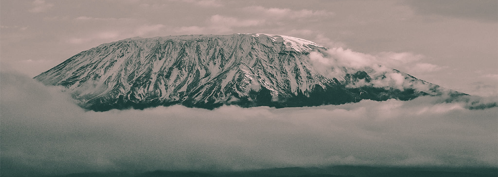
Of the seven main routes for climbing Mount Kilimanjaro, the Machame route is by far the most popular choice. About 50% of all climbers, choose the Machame route for good reason. The climbing is challenging, but not overwhelming. The scenery on the Machame route is absolutely amazing and by climbing to high altitude during the day and sleeping at a lower altitude at night.
The Machame route is better known as the Whiskey route, given its reputation for being a tough, but a rewarding climb. Unlike the gradual incline and hut accommodations found on the Marangu Route, the climbers that chose the Machame hike will find steeper trails, for longer distances, and will be sleeping in tents. Overall the Machame route is an excellent choice for climbing Mount Kilimanjaro.
- Day 1
Elevation: 1830m / 6000ft to 3050m / 9950ft
Distance: 11km / 7mi
Hiking Time: 5-6 hours
Habitat: Montane Forest
Drive from Arusha to Machame Gate takes about 45 minutes, or 1.5 hours from Arusha. The journey passes through the village of Machame which is located on the lower slopes of the mountain.
We depart the park gate and walk through the rain forest on a winding trail up a ridge. At lower elevations the trail can be muddy and slippery. Gaiters and trekking poles are a good idea here. We continue a short distance until we reach the Machame Camp.
- Day 2
Elevation: 3050m / 9950ft to 3850m / 12,600ft
Distance: 5km / 3mi
Hiking Time: 4-5 hours
Habitat: Moorland
After breakfast we leave the glades of the rain forest and continue on an ascending path, crossing the valley along a steep rocky ridge. The route now turns west onto a river gorge until we arrive at the Shira campsite.
- Day 3
Elevation: 3850m / 12,600ft to 4000m / 13,000ft
Distance:10km / 6mi
Hiking Time: 5-6 hours
Habitat: Semi - Desert
From the Shira Plateau we continue to the east up a ridge, passing the junction towards the peak of Kibo. As we continue, our direction changes to the South East towards the Lava Tower, called the “Shark’s Tooth” (elev 4650m/15,250ft). Shortly after the tower we come to the second junction which goes to the Arrow Glacier. We now continue down to the Barranco Camp. Although you end the day around the same elevation as when you began, this day is very important for acclimatization and will help your body prepare for summit day.
- Day 4
Elevation: 4700m / 15,500ft to 5895m / 9,340ft
Distance: 6km/4mi up
Hiking Time: 6-8 hours
Habitat: Alpine Desert
After breakfast, we leave Barranco and continue on a steep ridge up the Barranco Wall (elev 4250m/13,900ft), through the Karanga Valley (elev 4050m/13,250ft) to the junction which connects with the Mweka Trail. We continue up to the Barafu Camp. You have completed the South Circuit, which offers views of the summit from many different angles. Here we make camp with views of the summit in the distance.
- Day 5
Elevation: 4700m / 15,350ft to 5895m / 19,340ft
Down to 3090m/10,150ft
Distance: 5km/3mi Up / 13km / 8mi down
Hiking Time: 5-7 hours up / 5-6 hours down
Habitat: Stone scree and Ice-Capped Summit
Very early in the morning (midnight to 2 am), we continue our way to the summit between the Rebmann and Ratzel glaciers. You head in a northwesterly direction and ascend through heavy scree towards Stella Point on the crater rim. This is the most mentally and physically challenging portion of the trek. At Stella Point you will stop for a short rest and will be rewarded with the most magnificent sunrise you are ever likely to see. Faster hikers may view the sunrise from the summit.
From Stella Point, you may encounter snow all the way on your 1-hour ascent to the summit. Once at Uhuru Peak you have reached the highest point on Mount Kilimanjaro and the continent of Africa!
From the summit we begin our descent by continuing straight down to the Mweka Camp, stopping at Barafu for lunch. You may want gaiters and trekking poles for the loose gravel going down. We arrive at Mweka Camp and enjoy our last evening on the mountain.
- Day 6
Elevation: 3090m /10,150ft to 1680m / 5500ft
Distance: 10km/6mi up
Hiking Time:3-4 hours
Habitat: Forest
After breakfast we continue the descent down to the Mweka Park Gate to receive your summit certificates. At lower elevations, it can be wet and muddy. Gaiters and trekking poles will help. Shorts and t-shirts will probably be plenty to wear (keep rain gear and warmer clothing handy).
African Rural Safaris vehicle will be waiting for you at Mweka gate to drive you back to your hotel in Arusha.
Quotation Includes;
- All accommodations as per itinerary
- 4X4 safari vehicle & Fuel
- Full-time English speaking driver/ guide
- All meals as indicated
- Park entrance fees
- Vehicle entrance fees
- Bottled mineral water while on safari
- All activities as indicated
Quotation Excludes;
- Tips
- Visa fees
- Air tickets
- All items of personal nature like laundry, phone calls, beer, e.t.c
- Personal trekking equipment such as sleepings bags, hiking boots, clothes, etc (available for renting)
- Liquors, beers and bottled beverages
- Anything else not included in the itinerary.